River News Network
World Weather & Mapping · Government Satellites · Agency Warnings
--:--:-- UTC● LIVE
Click a continent on the map, or type a place.
Earth, NASA Blue Marble
Satellite loop
Pick a place
—
Speed Layers
Rain estimate, NASA scale (mm/hr):NASA GPM precipitation rate legend
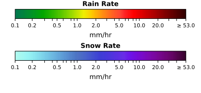
This is satellite cloud plus a satellite rain estimate. It is not radar. Frame times are the agencies' own.
Heavy-rain cells in this view
NASA GPM IMERG · satellite reading tier · floor 10 mm/hr
Reading NASA’s newest frame…
On the wire here
Agency statements inside this view · from RNN’s bus
Reading the bus…
    How to read this desk

    The picture is a government geostationary satellite (NOAA GOES, EUMETSAT Meteosat, JMA Himawari) at its own cadence, with NASA’s GPM rain estimate drawn in colour. The rain frame runs hours behind the cloud frame; both print their own time.

    The words are whatever agency has spoken about this place on RNN’s wires. Where none has, the desk says so. RNN never writes a warning of its own.

    Cities come from the US Census gazetteer and Natural Earth. A projection for a US city is the National Weather Service’s own forecast, quoted. Elsewhere it is labelled model data unless a national service is on the wire.